Feeds:
Posts
Comments

Posts Tagged ‘tectonics’

 
Japan Earthquake
Watching the earthquakes in Japan and following tsunami happen in near real time was to say the least, heart wrenching.  Further threats from aftershocks, nuclear power plant  meltdowns, radiation poisoning, poor weather conditions, power outages, and a lack of basic supplies only compound the magnitude of the crisis.  Throw in a volcanic eruption for measure in Japan at-http://www.timeslive.co.za/world/article965229.ece/Japanese-volcano-erupts
More than 200 magnitude 5 (and above) aftershocks have been recorded in Japan since the first quake on Friday.
Frequent readers at Ahrcanum (hint, hint, subscribe in the sidebar for updates or follow us on twitter) know that we’ve written about numerous catastrophic events with a conspiracy twist.  Last year in 2010, both Chile and Japan were hit with large quakes that raised our antennae to the possibility that these events may have been caused by man. https://ahrcanum.wordpress.com/2010/02/27/chile-japan-earthquake-conspiracy/ The last 9M quake that we recall, was the 9.1M quake off the coast of Sumatra in 2004 that killed and estimated 228,000 people.

It has taken us days to absorb the magnitude of another 9.0M earthquake.  What more could we say that others have expressed so eloquently?  As reports began with a 100 dead, we immediately knew these numbers were destined to rise with new reports nearing 10,000 people dead and bodies lining shorelines and buried in the mud. 

Were there warnings by nature across the globe that went unheeded? http://au.news.yahoo.com/thewest/a/-/offbeat/9000351/tsunami-linked-to-fishy-phenomenon/ reported of huge schools of fish being so close to shore that fisherman were out with buckets in Acapulco about the same time as the earthquake hit in Japan. 

A couple troll their little boat through a mass of dead fish in the King Harbor Marina.

Just days before, millions of anchovie were found dead with reports of  fish kills in California, dead seals New Jersey and dead dolphins along the Gulf Coast. Previously reviewed in this article at https://ahrcanum.wordpress.com/2011/01/05/birds-falling-from-sky-%e2%80%93-blame-haarp-flu-poison-or-climate-change/

The cause of the die-off is nearly always decaying algae. Although the oceans are awash in algae, these microscopic organisms bloom when fed by nutrients such as fertilizers and human and animal waste washing off the land. Stoked by such nutrients and exposed to sunlight, algae flourish and then die and sink to the bottom. Bacteria then take over, breaking down the plant matter and sucking the oxygen out of seawater. That leaves little or none for fish and other marine life.  http://latimesblogs.latimes.com/lanow/2011/03/redondo-beach-dead-fish-oxygen-levels-zero.html

One commentator, Kevin on the article wrote:

Earth is undergoing a magnetic reversal. Fish use magnetic polaraty to navigate like a GPS system. No red tide caused them in here. A magnetic anomaly did. They swam against the wall agressivly and with out end till they died off from cardiac arrest.

A magnetic anomaly?  Decaying algae?  Hummm.  There were rumors of another wormhole sort of blue spiral over Russia just days before on, March 10, 2011. The video is located at http://www.youtube.com/watch?v=aV46DnxlBGs&feature=player_embedded#at=71 A test practice for the capabilities of HAARP?

Could HAARP truly unleash the power to create an underground tectonic plate shift that resulted in Japan moving 2.4 meters, according to http://au.news.yahoo.com/thewest/a/-/breaking/9002233/quake-moves-japan-2-4m/

www.notanotherconspiracy.com has done our homework for us by posting the magnometer readings from Alaska, (which is in part a joint consortium with Japan) during the time of the earthquake. Obviously the charts reflect some increase as expected.  The question lurks if an array can cause enough heating of the magnetosphere to not only record an event but, perhaps cause an event?

The Atlantean Conspiracy http://www.atlanteanconspiracy.com/2011/03/japan-tsunami-caused-by-haarp.html  points out that HAARP was basically flatlined in the days before the quake.  Coincidence?

And, what was CERN up to? http://greybook.cern.ch/programmes/EXP_NAM.html A whole lot of particles on any given day that just happened to restart, “at the weekend,” according to http://www.reuters.com/article/2011/03/14/us-science-cern-idUSTRE72D5DR20110314.  Another hummm?

“We can not rule out the possibility of an explosion”, said Chief cabinet Secretary Yukio Edano on Sunday regarding Unit 3 of the Fukushima Dai-ichi nuclear complex.  Unit 1 exploded Saturday resulting in tens of thousands, if not hundreds of thousands of people evacuating the area. Today, Monday March 14, 2011 there are reports if addional explosions at Unit 3 and reports of radiation contamination.

Efforts that amount to a Hail Mary Pass might as well turn to only saying  Hail Mary prayers for the people of Japan and what effects a nuclear release of radiation will have; wherever the clouds may blow.  If you do not think those clouds from Japan can and will blow over the U.S.A., you are sadly mistaken. 

As for Coronal Mass Ejections- we have seen our fair share as of late, but really nothing that should trip this kind of trigger.  But, Piers Morgan with Info Wars affiliation says the massive earthquake and tsunami were triggered by massive events on the sun and that there are more to come in the next two years.

So we may glance at the moon and its predictions this week of super powers from a supermoon.  This week, March 19 will bring a full moon that will bring perigee when the moon is closest to the Earth. http://www.huliq.com/10557/scientists-say-supermoon-had-no-role-japan-tsunami Will we see more earthquakes, additional volcanic eruptions?

An earthquake can move the earth’s axis and change the length of the time of day and shift the alignment of the poles according to NASA at, http://www.nasa.gov/home/hqnews/2005/jan/HQ_05011_earthquake.html.  The inertia of a predicted pole shift anticipated for 2012 is significantly twisting our antennae as well.

Is The Great Japanese Earthquake the beginning of the end for the 3rd largest economy in the world?  A sign of things to come? A sign of things ending? Recent reports are of 965 micro sieverts have been measured in the area surrounding the latest nuclear plant explosion with the mayor saying Tokyo has now started monitoring radiation.  This is the same, “Tokyo mayor Ishihara alleges tsunami is “heavenly retribution for Japan’s greed.”

What words could we write to say how insensitive Ishihara’s statement is, and that you Sir are an ass? 

Just how long until the California coastline is affected?  Stay tuned. 

Follow:

Earthquakes in Japanese http://typhoon.yahoo.co.jp/weather/jp/earthquake/ 

USGS a quake list for 10 -degree map centered at 35N, 140E, the Honshu Region- http://earthquake.usgs.gov/earthquakes/recenteqsww/Maps/10/140_35.php 

Live UStream TV Japan http://www.ustream.tv/channel/nhk-gtv

Aljazeera TV in English at   http://english.aljazeera.net/watch_now/

Top of Page, Japan earthquake image credits to http://www.allvoices.com/cartoons/c/75086966-Japan-Earthquake#parent_comment_div


 flag tounge      

Open wide, say ahhh and check out more posts from Ahrcanum!   

Shaking, rattling and rolling into the conspiracy, truth and science of EARTHQUAKES, HAARP, EISCAT, Tesla, etc., with more posts at https://ahrcanum.wordpress.com/earthquakes-haarp/       

Help spread the word.  SUBSCRIBE  NOW and Follow us on Twitter (by clicking in the side margin) or sign up at http://twitter.com/ so you can get the latest updates as soon as they’re posted. Make sure to re-tweet, so all your friends get the heads up too.         

 CITE THIS SOURCE or may the fleas of  a thousand camels infest your armpits.

Read Full Post »

Earthquakes are slamming Alaska today as the Solar Storm continues to pummel the earth with geomagnetic activity. 

This morning a Magnitude 6.3 Earthquake struck the  ANDREANOF ISLANDS, ALEUTIAN IS., ALASKA. at 2010 August 04 12:58:24 UTC http://earthquake.usgs.gov/earthquakes/recenteqsww/Quakes/us2010znbf.php

6.3M is nothing to shake a stick at. 

HAARP’s magnetometers were fairly calm until the start of the solar storm, kicked off by Sunspot 1052.  It is now picking up significant anomalies in the magnetosphere.  The three traces represent mutually orthogonal components of the earth’s magnetic field as follows:

  • The “H” component (black trace) is positive magnetic northward
  • The “D” component (red trace) is positive eastward
  • The “Z” component (blue trace) is positive downward

HAARP Magnetometer Chain

Real-time monitoring of the Earth’s magnetic field, Data for research and practical application from USGS  is showing major spikes from Alaska all the way to Guam. You can view the real time data at  http://geomag.usgs.gov/realtime/, which supposedly demonstrates a wide dispersal of geomagnetic energy affecting far apart distances. 

As we grab for our tinfoil hat, the Station- CMO Fairbanks, AK, located at 25.13°/212.14° at 197 meters, went OFFLINE BEFORE the quake hit.  It was picked up at almost all reporting stations including as far as the station at SJG, Cayey, PR,71.89°/293.85°, 424 meters.

Scientifically,we are under a solar storm alert, all be it, a supposed minor one.   http://www.swpc.noaa.gov/SWN/index.html NOAA Alerts / Bulletins
Latest Alert: Aug 04 1032 UTC ALERT: Geomagnetic K-index of 5.  Yesterday in was an index of 4. 

Latest GOES Solar X-ray Image, 2010 Aug 04 15:25 UTC (Aug 04 09:25 MDT)

Spacequakes have been going on for sometime in our universe, but now we have a model prediction thanks to the satellites circling the Sun. 

In 2007, THEMIS discovered the precursors of spacequakes. The action begins in Earth’s magnetic tail, which is stretched out like a windsock by the million-miles-per-hour solar wind. Sometimes the tail can become so stretched and tension-filled, it snaps back like an over-torqued rubber band.

Solar wind plasma trapped in the tail hurtles toward Earth. On more than one occasion, the five THEMIS spacecraft were in the line of fire when these “plasma jets” swept by. Clearly, the jets were going to hit Earth. But what would happen then? The fleet moved closer to the planet to find out.

“Now we know,” said THEMIS project scientist David Sibeck of NASA’s Goddard Space Flight Center in Greenbelt, Md. “Plasma jets trigger spacequakes.”

According to THEMIS, the jets crash into the geomagnetic field some 18,600 miles (30,000 km) above Earth’s equator. The impact sets off a rebounding process, in which the incoming plasma actually bounces up and down on the reverberating magnetic field, akin to a tennis ball bouncing up and down on a carpeted floor. The first bounce is a big one, followed by bounces of decreasing amplitude as energy is dissipated in the carpet.  http://ca.news.yahoo.com/s/yahoocanada/100728/canada/violent_spacequakes_shake_earth_from_above

If plasma bounces up and down on the reverberating magnetic field after it crashes someplace above the equator, could it have bounced on over to Alaska to cause this earthquake and the one earlier today- Magnitude 6.4 – EASTERN NEW GUINEA REG, PAPUA NEW GUINEA,  2010 August 04 07:15:33 UTC http://earthquake.usgs.gov/earthquakes/recenteqsww/Quakes/us2010znav.php?

That’s a pretty big bounce.

If the satellites can observe CME’s from the Sun, is there nothing NASA has available to track where the plasma impact occurs on Earth? 

Could this solar alert provide a perfect covert opportunity for advanced weapons experiments using SCALAR weapons?  What are the chances that a station goes off line in the vicinity of an earthquake before one hits?  Could HAARP have fired a beam up to heat the ionosphere causing the quake?

What of Accelerator-based experiments shooting particles through the Earth? A solar storm is the perfect storm to attempt some new experiment that could cause of quakes and disruptions.

The neutrinos are generated at CERN when a proton beam from the Super Proton Synchrotron strikes a target, producing pions and kaons. These quickly decay, giving rise mainly to νμ that pass unhindered through the Earth’s crust towards Gran Sasso. The appearance and subsequent decay of a τ in the OPERA experiment would provide the telltale sign of νμ to ντ oscillation through a charged-current interaction. http://cerncourier.com/cws/article/cern/43178

Recall that the San Grasso Lab was almost ground zero for the Italy Quake!

While this solar storm seems minor, millions of people are getting there first opportunity to see the aurora borealis with a wider than normal viewing area depending on the weather

Auroral Activity Extrapolated from NOAA POES

With all that energy, could a wormhole form due to the magnetic properties of the north pole, interacting with the solar winds?  Shall we send our politicians for a look?

While Alaska and New Guinea are rattling, finally at BP at the  Deep Water Horizon Oil Spill in The Gulf of Mexico, “claimed “a significant milestone” in efforts to plug a leaking well for good on Wednesday ahead of a U.S. government report that will show most of the spilled crude is already gone.

“The good news is that the vast majority of the oil appears to be gone,” Carol Browner said on ABC’s “Good Morning America.”

 A New York Times story said the report would show three-quarters of the oil released has already evaporated, dispersed, been captured or eliminated. http://ca.news.yahoo.com/s/reuters/100804/n_top_news/cnews_us_oil_spill

This too shall pass.  Until the next disaster, earthquake, experiment, etc.

flag tounge        

Open wide, say ahhh and check out more posts from Ahrcanum!        

Help spread the word.  SUBSCRIBE NOW and Follow us on Twitter (by clicking in the side margin) or sign up at http://twitter.com/ so you can get the latest updates as soon as they’re posted. Make sure to re-tweet, so all your friends get the heads up too.        

 CITE THIS SOURCE, or may the fleas of a thousand camels infest your armpits.

Read Full Post »

As a Solar Storm is heading to Earth, the conspiracy rattles on with reports of high magnitude earthquakes and unusual Magnetometer chart readings from HAARP and USGS. 

Magnitude 5.3 – SOUTHWEST OF SUMATRA, INDONESIA 2010 August 03 08:03:18 UTC http://earthquake.usgs.gov/earthquakes/recenteqsww/Quakes/us2010zmat.php

Magnitude 5.0 – OFFSHORE TARAPACA, CHILE  2010 August 03 05:29:21 UTC http://earthquake.usgs.gov/earthquakes/recenteqsww/Quakes/us2010zmaq.php

Magnitude 6.3 – MOLUCCA SEA 2010 August 03 12:08:26 UTC http://earthquake.usgs.gov/earthquakes/recenteqsww/Quakes/us2010zma4.html

Magnitude 5.4 – TAJIKISTAN 2010 August 03 16:26:27 UTC http://earthquake.usgs.gov/earthquakes/recenteqsww/Quakes/us2010zmbf.php

Yadda, yadda.  There are earthquakes everyday, but it is not everyday that the Sun hurls giant Coronal Mass Ejections towards the Earth’s magnetosphere.  On August 1st, a flare, shockwave, filament eruption and CME erupted on the Earth-facing side of the sun.  The CME is heading directly for us — see the SOHO video of the CME.  The storms arrival time? August 3rd, 2010, TODAY.

Solar Sunspot 1092. Image: Oleg Toumilovitch, July 31st, rising over Blairgowrie, South Africa.

NASA’s Solar Dynamics Observatory (SDO) and the NASA/ESA Solar and Heliospheric Observatory (SOHO) detected the C3-class solar flare, sunspot #1092.

After sunset,  look west and you will see Venus, Saturn, and Mars have converged to form a triangle.  You will also see the Summer Triangle – technically an asterism, rather than a constellation – formed by the stars Vega, Altair and Deneb.  (https://ahrcanum.wordpress.com/2010/08/01/illuminati-triangle-in-the-sky/)  

Scientists said residents of northern regions — possibly including Seattle, as well as parts of Michigan and Maine — may see an unusual display of the aurora borealis, the northern lights. http://www.mercurynews.com/top-stories/ci_15661076?nclick_check=1

NOAA forecasters estimated a 10% chance of major geomagnetic storms and a 45% chance of at least some geomagnetic activity when the clouds arrive on August 3rd and 4th. via http://spaceweather.com/  Wouldn’t you like nearly 50% odds of hitting the lottery? 

Translation, we’ve got a 50% chance that we’re going to have some geomagnetic activity that may or may not cause satellite interference and communications malfunctions here on earth.   The earth, so delicately balanced also relies on the magnetosphere and ionosphere to protect it from upheaval.  NOAA / Space Weather Prediction Center reassures us all is calm, all is bright, all is all right.

Alerts / Bulletins
Latest Alert: Aug 03 1827 UTC WARNING: Geomagnetic K-index of 4 expected
Last Advisory Bulletin: None in last 7 days.

It would seem likely that if the Earth’s atmospheric magnets are going out of whack so is the Earth, and possibly the cause of an increase in earthquakes and volcanoes.

The scientists will tell you about plate tectonics causing earthquakes.  Most recently is a new theory out of  Purdue University.

Earthquakes, “came from stored stress built up in the Earth’s crust long ago…Our theory links an external climate-driven process, the melting of the ice sheet, and earthquakes…Unfortunately, this stored stress is invisible to us.” via US News & World Report Science at  http://ht.ly/18pBTL

That’s one theory.  No matter, all the Earth’s Observatories should be in ready, set, go, mode to record some impressive atmospheric activity..

We’ve asked  it time and time again if the High Frequency Active Auroral Research Project (HAARP), is a scientific advance of  knowledge or a system of destruction capable of causing earthquakes, tsunami, and otherwise “natural disasters?” https://ahrcanum.wordpress.com/2010/01/18/haiti-earthquake-conspiracy-haarp-patents-arecibo/.  What about EISCAT, SURA and the worlds other large arrays?  Do you think they only receive and not emit?

The Arecibo Observatory is the largest and most sensitive radiotelescope.  It sits atop the seismically active Puerto Rico Trench, and ever so close to Haiti.    You can download data from the Arecibo dual-frequency ASHTECH MicroZ-CGRS GPS receiver and high quality choke-ring antenna.  http://www.naic.edu/aisr/GPSTEC/gpstec.html.   Sadly, it offers no real time data and is only up to releasing the 90th day of the year’s activity. A lot of good that does for now.

What are the volcano’s doing?  The  SI / USGS Weekly Volcanic Activity Report  doesn’t come out until tomorrow.   http://www.volcano.si.edu/reports/usgs/

Real-time monitoring of the Earth’s magnetic field, Data for research and practical application from USGS main page work offering real time data and presently lots of spikes, UTC 24hr Time of last update 19:00 UTC 24hr Time.

BRW
Point Barrow, AK
18.68°/203.38°
12 meters
DED
Deadhorse, AK
19.64°/201.21°
10 meters
CMO
Fairbanks, AK
25.13°/212.14°
197 meters
SIT
Sitka, AK
32.94°/224.67°
24 meters
SHU
Sand Point, AK
34.65°/199.54°
80 meters
NEW
Newport, WA
41.73°/242.88°
770 meters
BOU
Boulder, CO
49.86°/254.76°
1682 meters
BDT
Boulder, CO
49.86°/254.76°
1682 meters
FRD
Corbin, VA
51.80°/282.63°
69 meters
FRN
O’Neals, CA
52.91°/240.28°
331 meters
TUC
Tucson, AZ
57.83°/249.27°
946 meters
BSL
Stennis, MS
59.65°/270.37°
8 meters
HON
Ewa Beach, HI
68.68°/ 202.00°
4 meters
SJG
Cayey, PR
71.89°/293.85°
424 meters
GUA
Dededo, Guam
76.41°/144.87°
140 meters

Would ya look at those Spikes in the last hour or so!  The impressive thing is that the spikes are being picked up at ALL of the Stations.  http://geomag.usgs.gov/realtime/

Let’s have a look at what our tax dollars are buying at HAARP.

HAARP Fluxgate Magnetometer, August 3, 2010.

The chart above is a running 36 hour plot of the readings taken from the fluxgate magnetometer, built by the University of Alaska, Geophysical Institute, operating at the HAARP ionospheric observatory in Gakona, Alaska. The three traces represent mutually orthogonal components of the earth’s magnetic field as follows:

  • The “H” component (black trace) is positive magnetic northward
  • The “D” component (red trace) is positive eastward
  • The “Z” component (blue trace) is positive downward

Hmmm, looks like a split in the road between the red and the black.  We have never seen such an anomaly at the same time.  There is only one positive North.  Here something is creating two positives at the same time.

Is that possible?  We are positively confused.

More confusing, shortly after uploading these graphs, lo and behold, another earthquake. http://earthquake.usgs.gov/earthquakes/recenteqsww/Quakes/us2010zmby.php

MAP  5.4   2010/08/03 19:42:14    -9.452    39.066  10.0   TANZANIA

#####

Open wide, say ahhh and check out more posts from Ahrcanum!        

Help spread the word.  SUBSCRIBE NOW and Follow us on Twitter (by clicking in the side margin) or sign up at http://twitter.com/ so you can get the latest updates as soon as they’re posted. Make sure to re-tweet, so all your friends get the heads up too.        

 CITE THIS SOURCE, or may the fleas of a thousand camels infest your armpits. 

Read Full Post »

It should come as no surprise that scientists are warning Haiti that more earthquakes could be coming to Haiti in the coming months, as we first reported here https://ahrcanum.wordpress.com/2010/01/27/earthquake-prediction-for-haiti-and-sumatra/

PORT-AU-PRINCE (Reuters) – Haiti should be preparing for another major earthquake that could be triggered by the catastrophic one last month which killed up to 200,000 people and left the capital Port-au-Prince in ruins, experts say.

Teams of geophysicists, who have been tracking movements in the fault line that slashes across Haiti and into the Dominican Republic, came to the nation last week to measure changes in the Earth’s crust after the 7.0-magnitude quake on January 12. http://www.reuters.com/article/idUSTRE61033A20100201

Preliminary calculations by his group show the January 12 quake could be the “little kick” that sets off another temblor along the 186 mile fault where two regional tectonic plates have been scraping together for millions of years.  http://www.reuters.com/article/idUSTRE61033A20100201

A 186 mile fault line, that mainly devastated only one major city?  That’s what I call a kick in the ass.

Haiti Fault Lines, image C Pamela E. Jansma and Glen S. Mattioli

Oh pleeazzze, give me a break.  These poor people in Haiti are as prepared as they are ever going to be for the time being.  There is nothing to fall on their heads or trap them.  Like in the game of dominoes, it has already all fallen down.  Haiti was warned two years ago and still it did nothing, nor could it have.  

Haiti’s biggest worries no longer come from underground; but the threat of military, humanitarian and climate interference. 

President Bellerive told CNN in an interview broadcast on Sunday that he was worried about the risk of illegal adoptions and child trafficking. “We have already reports of a lot of trafficking (of children) and even of organ trafficking,” he said, while citing no specific cases.  Yeah, like those scary Baptists taking kids to an orphanage.http://www.haitifeed.com/2010/02/01/haiti-orphan-rescue-mission-adoption-or-child-trafficking-christian-science-monitor/ 

Mark Fried from Oxfam in a recent podcast http://www.oxfam.org/haitiquake  has hit the nail on the head- what are all these people going to do when the rainy season starts in April?  Besides getting being wet, there are going to mudslides due to the destruction blocking the rains natural runoff patterns.   Say nothing of the possibility of fire from thousands cooking under makeshift sheets and tents. 

These people have more to worry about than another shimmy shake.  

 flag tounge           

Open wide, say ahhh and check out more posts from Ahrcanum!     

Our Swine Flu Report that began in April is at https://ahrcanum.wordpress.com/swine-flu-report         

Shaking, rattling and rolling into the conspiracy, truth and science of EARTHQUAKES, HAARP, EISCAT, Tesla, etc., with more articles at https://ahrcanum.wordpress.com/earthquakes-haarp/      

Help spread the word.  SUBSCRIBE  NOW and Follow us on Twitter (by clicking in the side margin)  so you can get the latest updates as soon as they’re posted. Make sure to retweet, so all your friends get the heads up too.

Read Full Post »

Mars at opposition in 2003. Image credit: NASA, J. Bell (Cornell U.) and M. Wolff (SSI)

The pole shift theory and Chandler’s Wobble come to mind today as the Earth will be between the Sun and the planet Mars, in what scientists refer to as being in opposition.  

For visual observers, the best display comes on Friday, Jan. 29th, when the full Moon and Mars converge for a floodlamp-bright conjunction. On that night, Mars will be at opposition—i.e., directly opposite the sun. It will rise alongside the Moon at sunset and soar overhead at midnight, never straying more than about 6o from the first full Moon of 2010. http://science.nasa.gov/headlines/y2010/26jan_mars.htm  

The last time this alignment occurred was August 29, 2003 when the  mars hoax made it’s way through the news.   “Mars will look as large as the full moon,” it says. “No one alive today will ever see this again.”  http://science.nasa.gov/headlines/y2009/09jun_marshoax.htm  Nothing noteworthy in the history books happened then, although Hurricane Katrina hit two years later, August 29 in 2005.   

As Mars approached in 2003, there was no full moon, it was a new moon.   http://www.skyscript.co.uk/moontab.html 

New Aug 27 17:26 04° Virgo 02′

The apogee and perigee of the moon have a definite affect on the weather and tides here on Earth. When the moon is at Apogee, the furthest distance from the Earth, it has less gravitational pull. Weather conditions can be more stable and the tides more predictable. When the moon is at perigee, closer to the Earth, there is much more gravitational pull and it can whip up the tides and cause weather to become more unstable. http://www.moonconnection.com/apogee_perigee.phtml  

The alignment of Mars this time occurs during a full moon!  With the moon impacting the Earth’s gravity, could this alignment offer a relationship between the rotation and the magnetic polarity of Earth, which does change irregularly, with a magnetic reversal or what some doomsday theorists claim, a pole shift?

The Chandler wobble is a small motion in the Earth’s axis of rotation relative to the Earth’s surface.  http://en.wikipedia.org/wiki/Chandler_wobble Will this alignment and potentially significant gravitational pull have enough impact to shift the earth entirely?  Could communications be disrupted say nothing of quakes, tsunami’s, volcanoes, etc.

Skymap for Jan. 29, 2010   

The Phoenix Paradigm explores a link to earth disasters like earthquakes examining predictions of Edgar Cayce with these excerpts, via http://www.michaelmandeville.com/earthchanges/vortectonics/Phoenix_Paradigm.pdf   

 
38. A shifting of the poles began with a shift of equilibrium inside the Earth in approximately 1936. The average location of the pole jumped a few feet volcanic and earthquake activity which persisted for nearly 15 years. This relationship provided the first datum for understanding the dynamics of the Earth-Phoenix. All earthquake and volcanic activity is directly created by motions of the crust of the Earth as it wobbles in Chandler’s Wobble. This constant motion of the crust, and thus the apparent movement of the location of the poles of the spin axis, is induced directly by orbital mass relationships in the Earth-Moon-Sun system and the variable forces in the solar flux. This concept and correlation is called “Vortex Tectonics”.   

39. As predicted by Edgar Cayce, the 1936 shift also set off major trends of motion and tectonic activity which began to appear in 1958 and slowly accelerated throughout the remainder of the 20th century to peak at a high level of accelerated activity in 1998. Volcanic and earthquake activity  dramatically increased each decade since the middle of the 20century in a linear, escalating pattern which cannot be explained by any conventional means.    (emphasis mine)

As stated by Edgar Cayce, correlations of the trends and activities of the last  100 years of earthquake and volcanic activity demonstrate clear  relationships with plots of the apparent X Wave Motion of the North Pole  (spin axis). Repeating bursts of increased tectonic activity in various  locations are definitely found associated with the X Wave Min (movement)  of England away from the North Pole) or the X Wave Max (movement of England towards the North Pole).  

The Phoenix Paradigm does not have a happy ending predicting significant earth changes and loss of life.  http://www.michaelmandeville.com/earthmonitor/polarmotion/polar_motion_monitor.htm#add_music has more on the topic with charts illustrating an uptick in tectonic activity.    

One thing for sure, we are not heading back to the moon anytime soon under the Obama budget. http://www.msnbc.msn.com/id/35131431/ns/technology_and_science-space/   

The money in the president’s budget is not enough to follow through with NASA’s Constellation moon landing plan initiated by President George W. Bush in 2004. An aide to an elected official who was told of Obama’s plans said the president is effectively ending the return-to-the-moon effort, even though $9.1 billion has already been spent.  

We seem to be more interested in Mars.  Ironically or pre-planned, Cassini made its closest approach to Mars yesterday. 

Read Full Post »

Scientists can detect a minuscule solar flair from the sun but they claim they can not predict earthquakes? http://www.swpc.noaa.gov/today.html

Now researchers believe they can possibly predict additional quakes in Sumatra and Haiti.

The earthquake that rocked Padang, western Sumatra, in September last year, killing more than 1000 people, was not the “great earthquake” that earth scientists are waiting for.  In fact, it may have made the next massive earthquake more likely, according to University of Ulster earthquake expert John McCloskey. That is the key conclusion of a paper published last week in the journal Nature Geoscience, the authoritative earth sciences research journal. http://alertnet.org/db/blogs/62815/2010/00/26-121510-1.htm

Going on to say:

For some years now scientists have been warning of the build up of stress on one of the earth’s great plate boundaries to the west of Sumatra in Indonesia. For more than 200 years the collision between the Indian ocean plate and the Asian plate has stored an enormous amount of energy. “It’s just like slowly drawing a bow. For hundreds of years the energy is stored as the two tectonic plates bend and deform. Then, in just a few seconds all this energy is released generating a massive earthquake and sometimes flexing the seafloor to create a tsunami.

In a few seconds, Haiti was demolished on January 12, 2010 with no warnings of preceding tremors, and no tsunami after. 

A team funded by the National Science Foundation (NSF) is returning to Haiti this week to investigate the cause {emphasis mine) of the January 12, magnitude 7 earthquake there.  The geologists will collect crucial data to assess whether the quake could trigger another major event to the east or west of Port-au-Prince, Haiti’s capital. Eric Calais, a Purdue University geophysicist leading the team, said that most aftershocks occur within weeks of the initial quake and that the team urgently needs to get to the site to make a detailed assessment before crucial geological information disappears.  http://www.sciencecodex.com/scientists_return_to_haiti_to_assess_possibility_of_another_major_quake

Where is the geological information disappearing to?  Investigate the cause?  Natural science would tell us that the plates beneath the ocean shifted- and that has been the official cause of every other earthquake reported in the world.  No government or entity has ever come forward to say, “Hey look what we can do.”

Clearly the San Andreas Fault in California, U.S., remains quite visible.

The San Andreas Fault has not disappeared

According to the theory of continental drift, the earth’s surface is divided up into a dozen or so massive, rigid plates that rest on the earth’s more fluid mantle. Some of the plates, the oceanic plates, are under the ocean, and the others, which are much thicker and heavier, are the continental plates.  Convection currents running along the top of the mantle, created by the upwelling of new crust in some places and the sinking of old crust in others, move the plates at roughly 2.5 centimeters per year (Fig. 2). Baja California, for instance, is drifting quite rapidly––it is moving at the same rate in which your fingernails are growing! Collisions between plates result in the deformation of the earth’s crust and the uplift of mountains, and cause severe earthquake and volcanic activity as well. http://www.biog1105-1106.org/demos/106/unit08/2a.continentaldrift.html via Cornell University.

What makes Haiti so different, besides the fact it sits near some of the deepest waters of the world?   Could it be its close approximation to Puerto Rico’s negative gravity?

Above ground, scientists from Rochester Institute of Technology are sweeping the leveled city with high-tech imaging integrated into a small aircraft.

Funded by the World Bank (sic, imagine that)  and in collaboration with ImageCat Inc., the five-day flight is meticulously mapping the disaster zone to aid in crisis management and eventual reconstruction of the city…The LIDAR capability detects and measures collapsed buildings and standing structures damaged by the earthquake. At the request of the U.S. Geological Survey, Faulring is using LIDAR to map the fault line to estimate how much the earth moved. This information is critical to refinement of earthquake-risk prediction models. http://www.rit.edu/news/?v=47281

Prediction modelling is one thing, but this assumes only environmental issues and not man-made technology can alter the earth’s plates or atmosphere with the potential to cause earthquakes.  If you don’t think HAARP, EISCAT, Project Blue Beam and the host of other Tesla like technology couldn’t possibly cause an earthquake, I have water for you to drink from the moon.  We all know there is water there, we just bombed it as proof. 

Comment, you know you want to!

 flag tounge      

Open wide, say ahhh and check out more posts from Ahrcanum!

Our Swine Flu Report that began in April is at https://ahrcanum.wordpress.com/swine-flu-report    

Shaking, rattling and rolling into the conspiracy, truth and science of EARTHQUAKES, HAARP, EISCAT, Tesla, etc., with more articles at https://ahrcanum.wordpress.com/earthquakes-haarp/ 

Help spread the word.  SUBSCRIBE  NOW and Follow us on Twitter (by clicking in the side margin)  so you can get the latest updates as soon as they’re posted. Make sure to retweet, so all your friends get the heads up too.

Read Full Post »

The Haiti Earthquake was imminent.  Did they know it and not tell anyone?

“Recent research and observation have shown that the process of seismogenesis is not completely random — earthquakes tend to be localized in space, primarily on plate boundaries, and seem to be clustered in time more than would be expected for a random process.”  http://www.nature.com/nature/debates/earthquake/equake_frameset.html

Scientists who detected worrisome signs of growing stresses in the fault that unleashed this week’s devastating earthquake in Haiti said they warned officials there two years ago that their country was ripe for a major earthquake. Their sobering findings, presented during a geological conference in March 2008 and at meetings two months later, showed that the fault was capable of causing a 7.2-magnitude earthquake — slightly stronger than Tuesday’s 7.0 quake that rocked the impoverished country.  http://news.yahoo.com/s/ap/20100115/ap_on_re_us/us_haiti_earthquake_warning;_ylt=Am6c.rU89Pyw2Tu4jMA7kDOs0NUE;_ylu=X3oDMTNzbW9zdXNoBGFzc2V0A2FwLzIwMTAwMTE1L3VzX2hhaXRpX2VhcnRocXVha2Vfd2FybmluZwRjY29kZQNtb3N0cG9wdWxhcgRjcG9zAzMEcG9zAzEzBHB0A2hvbWVfY29rZQRzZWMDeW5fdG9wX3N0b3J5BHNsawNzY2llbnRpc3Rzd2E

24 hours before the Haiti Quake this earthquake warning was issued by Astrotometry at  http://www.youtube.com/watch?v=WwHwzqZg9M4 

Northern Hemisphere Earthquake Watch Until January 16th.  Entering a period of intense earthquake activity.  Astrotometry of recent holes in the solar corona indicate upcoming inconsistencies in the Earth’s hypertime translation. During the period January 11th to January 16th a very strong seismic event above 7.7 in magnitude is probable and several seismic events above 6 in magnitude are expected in the Northern Hemisphere.  Based on correlated cloud patterns, in order of probability, the quake-prone watch regions most likely to be effected are:

Indonesia
California
West Central Asia
Southeastern Europe (near Greece or Italy)
Hawaii

It’s probable that more than one region in the Northern Hemisphere will be effected during this period.  A separate coronal hole indicates a quake of lesser magnitude in the Solomon islands region in the Southern Hemisphere near the end of the watch period or shortly after.

http://neic.usgs.gov/neis/qed/  lists earthquakes that occurred in the same period, including Haiti.  

Pretty damned accurate, eh?

Giampaolo Giuliani, an expert at the Gran Sasso national laboratory, had  warned the authorities a week before the earthquake about some seismic activity he had been detecting in Central Italy but he was ignored by all but a few believers. https://ahrcanum.wordpress.com/2009/04/08/italy-earthquake-warnings-by-giampaolo-guiliani-dismissed/

There’s a 100 percent chance of an earthquake today. Though millions of persons may never experience an earthquake, they are very common occurrences on this planet. So today — somewhere — an earthquake will occur.http://earthquake.usgs.gov/learn/topics/100_chance.php

Let us remind you that the U.S. government was running drills- allegedly in the event a hurricane were to hit Haiti, just the day prior to the quake.  In light of the United States government SOUTHCOM and the Defense Department’s European Command,  ”preparing for a test of the system in a scenario that involved providing relief to Haiti in the wake of a hurricane. After the earthquake hit on Tuesday, Demay said SOUTHCOM decided to go live with the system.”   https://ahrcanum.wordpress.com/2010/01/22/haiti-earthquake-conspiracy-southcom-drill-prior-to-quake-reminiscent-of-911/

Another prediction or coincidence?

 flag tounge      

Open wide, say ahhh and check out more posts from Ahrcanum!

Our Swine Flu Report that began in April is at https://ahrcanum.wordpress.com/swine-flu-report    

Shaking, rattling and rolling into the conspiracy, truth and science of EARTHQUAKES, HAARP, EISCAT, Tesla, etc., with more articles at https://ahrcanum.wordpress.com/earthquakes-haarp/ 

Help spread the word.  SUBSCRIBE  NOW and Follow us on Twitter (by clicking in the side margin)  so you can get the latest updates as soon as they’re posted. Make sure to retweet, so all your friends get the heads up too.


Read Full Post »

Magnitude 6.1 – HAITI REGION

2010 January 20 11:03:44 UTC

The earthquake conspiracy in Haiti continues.  http://earthquake.usgs.gov/earthquakes/recenteqsww/Quakes/us2010rsbb.php

Is it a coincidence that there there so many experiments going on at the antennas and arrays of the world in relationship to ionospheric-heating and weather control? 

What benefit could there be to unleashing an ionospheric heating experiment or some other catastrophic device, especially in the vicinity of Haiti?  Jan. 17, 2010 the  USGS Earth Science Information Center (ESIC) released this:

The Orinoco Oil Belt Assessment Unit of the La Luna-Quercual Total Petroleum System encompasses approximately 50,000 km2 of the East Venezuela Basin Province that is underlain by more than 1 trillion barrels of heavy oil-in-place. As part of a program directed at estimating the technically recoverable oil and gas resources of priority petroleum basins worldwide, the U.S. Geological Survey estimated the recoverable oil resources of the Orinoco Oil Belt Assessment Unit. … The U.S. Geological Survey estimated a mean volume of 513 billion barrels of technically recoverable heavy oil in the Orinoco Oil Belt Assessment Unit of the East Venezuela Basin Province; the range is 380 to 652 billion barrels. The Orinoco Oil Belt Assessment Unit thus contains one of the largest recoverable oil accumulations in the world. via http://pubs.er.usgs.gov/usgspubs/fs/fs20093028?from=home

Anyone having control over this region would certainly be in good economic position.

Where might some of these experiments have been taking place at recently?


The Poker Flat Research Range, via wiki http://en.wikipedia.org/wiki/Poker_Flat_Research_Range    http://www.pfrr.alaska.edu/pfrr/index.html for the home page.

(PFRR) is a launch facility and rocket range for sounding rockets in the U.S. state of Alaska owned and operated by the University of Alaska Fairbanks (UAF) Geophysical Institute since 1968. The world’s largest land-based rocket range, it is situated on a 5,132-acre (20.7 km2) site located approximately 30 miles (48 km) northeast of Fairbanks and is operated under contract to the NASA Wallops Flight Facility. Since its inception PFRR has been closely aligned and funded by the Defense Threat Reduction Agency and its predecessor, the Defense Nuclear Agency (DNA). Other range users include the United States Naval Research Laboratory (NRL), the Air Force Geophysics Lab (AFGL) and a number of Universities and research laboratories. More than 1,700 launches have been conducted at the range to study the Earth‘s atmosphere and the interaction between the atmosphere and the space environment .[1] Areas studied at PFRR include the aurora, plasma physics, the ozone layer, solar proton events, Earth’s magnetic field, and ultraviolet radiation

…under contract to NASA’s Wallops Flight Facility, which is part of the Goddard Space Flight Center. In addition to launching sounding rockets, Poker Flat is home to many scientific instruments designed to study the arctic atmosphere and ionosphere.http://www.pfrr.alaska.edu/

Would Haiti be too far to study or influence?  January’s schedule can be found at http://sched.wff.nasa.gov/wffsched/ with experiments listed each day.

January 12, 2010 scheduled activities the day a  7.0 magnitude quake in Haiti:

  12
0700
SR-BLACK BRANT IX 36.247
0800
Transition of Communications Ductbank (Z40-Z72)
1643
DMSP
2000
SR-BLACK BRANT IX 36.250
SR-BLACK BRANT IX 36.251

January 20, 2010 sceduled activities, the day a 6.0 magnitude quake in Haiti:

  20
GLOBAL HAWK
0700
SR-BLACK BRANT IX 36.247
0800
Transition of Communications Ductbank (Z40-Z72)
1300
OZONESONDE BALLOONS
2000
SR-BLACK BRANT IX 36.250
SR-BLACK BRANT IX 36.251
 
SR-BLACK BRANT IX 36.247
Date 01/20/2010  (GMT 01/20/2010 – 02/20/2010)
Time 0700  – 1530  (GMT 1200  – 2030)
Contact Theodore Gass
Theodore.B.Gass.1@gsfc.nasa.gov
Project Name/Vehicle ID BLACK BRANT IX
Project Number NRO-4732
Principal Investigator MARTI/USAF-ABL
Site Location San Nic (San Nicolas Island)

The name San Nicolas Island sounds like a beach vacation paradise, but is a US Navy owned and operated island.  Located 65 nautical miles southwest of the Point Mugu complex, San Nicolas Island is the cornerstone in the Sea Range capabilities.

Because of its instrumentation, isolated environment, shoreline characteristics, San Nicolas Island is utilized for test and training exercises, providing littoral warfare training, including tri-service and theater warfare exercises. It also offers an environment suited for classified operations. The main San Nicolas Island complex provides complete housing, dining, recreation, transportation, and public works support.

What else is on San Nicolas Island?  Giant telemetry collection facilities, known as antennas to you and me! 

San Nicolas Island has extensive telemetry collection facilities including three 30 ft, two 20 ft, one 8 ft, and 7 ft diameter antennas. Signals can be recorded and routed to the Point Mugu operations complex for best source selection. The SNI Telemetry Collection Facility also provides real-time reception, recording and relay of telemetry data. SNI supplies this telemetry data to Point Mugu for processing and display. Telemetry signals are received through land-based antennas located at SNI and sent in real-time by a fiber optic cable and/or microwave to Point Mugu. The best source signals are then sent by fiber optic cable to the TDC, located in the ROC for real-time processing and display. The SNI telemetry facilities are ideally located to support operations throughout the Sea Range as well as strategic and space launches from the Western Range (WR), Vandenberg Air Force Base (VAFB). The capability to record and display Miss Distance Indication (MDI) and video Doppler data is also available. Nearly all major users of the Sea Range rely on telemetry support from SNI. http://www.beachcalifornia.com/sannic_island.html

What is a Black Brant Rocket that appears to have a daily launch or intercept in January, 2010?

Black Brant Rockets are the result of research at CARDE during the 1950s into the nature of the upper atmosphere as part of ongoing research into anti-ballistic missile systems systems and very-long-range communication.  Starting in 1955 a serious effort to equip Canada with a useful anti-ballistic missile system was undertaken, along with research into the problems of detection and tracking, hypersonic flight, and fuels suitable for use in an interceptor missile. As part of this project a lengthy study of the upper atmosphere was undertaken from instrumented balloons. Another development from this era was the use of gun-fired models for high-speed testing, instead of using a wind tunnel. Led by Gerald Bull, the sabot-based system would go on to be used in Project HAARP during the early 1960s. 

On September 19, 2009, a Black Brant XII that was launched to study clouds caused numerous calls from the northeastern U.S. reporting “strange lights in the sky”. NASA reported that the light came from an artificial noctilucent cloud formed by the exhaust particles of the rocket’s fourth stage at an altitude of about 173 mi (278 km). http://en.wikipedia.org/wiki/Black_Brant_(rocket)

NASA reported that the light came from an artificial noctilucent cloud formed by the exhaust particles of the rocket’s fourth stage about 173 miles high.The Blast caused numerous citizens to file reports on the “strange lights in the sky” with the media and government from Virginia up to Boston. The Charged Aerosol Release Experiment (CARE) was conducted by the Naval Research Laboratory and the Department of Defense Space Test Program using a NASA four-stage Black Brant XII suborbital sounding rocket. Using ground based instruments and the STP/NRL STPSat-1 spacecraft, scientists are studying an artificial noctilucent cloud formed by the exhaust particles of the rocket’s fourth stage at about 173 miles altitude….http://www.outlookseries.com/N2/Science/3618_Black_Brant_XII_Spooks_North_East_Strange_Lights_Artificial_Cloud.htm 

Can you spell chemtrails dropping aluminum oxide? http://chemtruth.ning.com/forum/topics/charged-aerosol-release

Like in the Sichuan quake, and more recently whatever the spiral was over Norway, strange lights in the sky are occurring, some naturally, and some man made.

Here is what one commentator saw over Hispaniola Jan12, 2010 left at this post https://ahrcanum.wordpress.com/2010/01/14/haiti-earthquake-conspiracy-haarp-eiscat/#comments  –


In other tests from EISCAT provided at http://www.eiscat.com/schedule/schedule.cgi.

1. On the day of the quake, 1-12-10 –http://www.eiscat.com/schedule/comment.cgi?fileName=2010011217646&Start=2200&End=2400  A study on meteor cross section form utilizing the polarization feature- 

2.  On the day of the quake 1-12-10,…to use the LT4 pulse code, but this will change to the ARCS pulse code if high energy precipitation studies are required. Use will also be made of the ASK and SIF optical instruments, which are also located on Svalbard.   This investigation is a collaboration with Sweden http://www.eiscat.com/schedule/comment.cgi?fileName=2010011223631&Start=0400&End=1100 

January 20, 2010 scheduled activities, the day a 6.0 magnitude quake in Haiti in the EICAT schedule of tests is the continuing Stratospheric warming experiment and a study of velocity distributions of precipitating electrons and outflowing ions with the ionospheric ion upflows/polar wind using the Reimei  satellite and ESR:

2010:01:20 Wed CCCCCCCCCCCCCCCCCCCCCCCCCCCCCCCCCCCCCCCCCCCCCCCCC ESR CP2 CP(750) 

2010:01:20 Wed CCCCCCCCCCCCCCCCCCCCCCCCCCCCCCCCCCCCCCCCCCCCCCCCC UHF CP2 CP(750)

2010:01:20 Wed .       .       .11     .       .       .       . ESR Reimei_ESR NI(2.5)

Rocket launches and warming experiments; things that make you go hmmmmm. 

Is it a stretch of the imagination, your thoughts? 

Related Posts:  

Conspiracy Haiti, Arecibo Observatory https://ahrcanum.wordpress.com/2010/01/18/haiti-earthquake-conspiracy-haarp-patents-arecibo/

Haiti, Listen to sound waves captured by HAARP https://ahrcanum.wordpress.com/2010/01/16/haiti-earthquake-conspiracy-haarp-sound-waves-listen/

Haiti Earthquake Conspiracy, HAARP, EISCAT Experiments on January 12, 2010  https://ahrcanum.wordpress.com/2010/01/14/haiti-earthquake-conspiracy-haarp-eiscat/#comments

Is HAARP causing Earthquakes & Ice to Melt?  https://ahrcanum.wordpress.com/2009/04/06/is-haarp-causing-the-earthquakes-volcanoes-to-erupt-and-the-ice-to-melt/

Italy Quake Warnings https://ahrcanum.wordpress.com/2009/04/08/italy-earthquake-warnings-by-giampaolo-guiliani-dismissed/

Italy Earthquake Conspiracy – https://ahrcanum.wordpress.com/2009/04/07/italy-earthquake-conspiracy/

Earthquake Epicenter near Nuclear Physics Lab https://ahrcanum.wordpress.com/2009/04/06/italy-earthquake-epicenter-near-nuclear-physics-lab/

WHAT Is That Noise in My Ears- https://ahrcanum.wordpress.com/2009/09/22/rining-noise-mosquito-whine-haarp-aliens-elf-implant/

South Pacific, Indonesia Quake Conspiracy https://ahrcanum.wordpress.com/2009/09/30/earthquake-conspiracy/ 

HAARP Causing the Quakes? https://ahrcanum.wordpress.com/2009/10/16/earthquake-haarp-connection-evidence/

Our thoughts and prayers remain with the people of Haiti, as well as the soldiers and aid workers there to help.

  flag tounge

Open wide, say ahhh and check out more posts from Ahrcanum including our Swine Flu report that began in April and is updated regularly at https://ahrcanum.wordpress.com/swine-flu-report

SUBSCRIBE NOW in the top right margin

Read Full Post »

The High Frequency Active Auroral Research Project (HAARP), a scientific advance of knowledge or a system of destruction capable of causing earthquakes, tsunami, and otherwise “natural disasters?”  

For your information, here are twelve patents. via http://www.padrak.com/ine/HAARP97.html Note carefully the titles.  

HAARP PATENTS (Assigned to APTI, Inc.)

U.S. Patent 4686605:
Method And Apparatus For Altering A Region In The Earth's Atmosphere,
  Ionosphere, And/Or Magnetosphere
Inventors:  Eastlund; Bernard J., Spring, TX
Assignees:  APTI, Inc., Los Angeles, CA
Issued:     Aug. 11, 1987
Filed:      Jan. 10, 1985

U.S. Patent 5038664:
Method For Producing A Shell Of Relativistic Particles At An Altitude
  Above The Earth's Surface
Inventors:  Eastlund; Bernard J., Spring, TX
Assignees:  APTI, Inc., Washington, DC
Issued:     Aug. 13, 1991
Filed:      Jan. 10, 1985

U.S. Patent 4712155:
Method And Apparatus For Creating An Artificial Electron Cyclotron
  Heating Region Of Plasma
Inventors:  Eastlund; Bernard J., Spring, TX
            Ramo; Simon, Beverly Hills, CA
Assignees:  APTI, Inc., Los Angeles, CA
Issued:     Dec.  8, 1987
Filed:      Jan. 28, 1985

U.S. Patent 5068669:
Power Beaming System
Inventors:  Koert; Peter, Washington, DC
            Cha; James T., Fairfax, VA
Assignees:  APTI, Inc., Washington, DC
Issued:     Nov. 26, 1991
Filed:      Sep.  1, 1988

U.S. Patent 5218374:
Power Beaming System With Printer Circuit Radiating Elements
  Having Resonating Cavities
Inventors:  Koert; Peter, Washington, DC
            Cha; James T., Fairfax, VA
Assignees:  APTI, Inc., Washington, DC
Issued:     June  8, 1993
Filed:      Oct. 10, 1989

U.S. Patent 5293176:
Folded Cross Grid Dipole Antenna Element
Inventors:  Elliot; Paul G., Vienna, VA
Assignees:  APTI, Inc., Washington, DC
Issued:     Mar.  8, 1994
Filed:      Nov. 18, 1991

U.S. Patent 5202689:
Lightweight Focusing Reflector For Space
Inventors:  Bussard; Robert W., Manassas, VA
            Wallace; Thomas H., Gainesville, FL
Assignees:  APTI, Inc., Washington, DC
Issued:     Apr. 13, 1993
Filed:      Aug. 23, 1991

U.S. Patent 5041834:
Artificial Ionospheric Mirror Composed Of A Plasma Layer
  Which Can Be Tilted
Inventors:  Koert; Peter, Washington, DC
Assignees:  APTI, Inc., Washington, DC
Issued:     Aug. 20, 1991
Filed:      May. 17, 1990

U.S. Patent 4999637:
Creation Of Artificial Ionization Clouds Above The Earth
Inventors:  Bass; Ronald M., Houston, TX
Assignees:  APTI, Inc., Washington, DC
Issued:     Mar. 12, 1991
Filed:      May. 14, 1987

U.S. Patent 4954709:
High Resolution Directional Gamma Ray Detector
Inventors:  Zigler; Arie, Rishon Le Zion, Israel
  Eisen; Yosset, Rishon Le Zion, Israel
Assignees:  APTI, Inc., Washington, DC
Issued:     Sep.  4, 1990
Filed:      Aug. 16, 1989

U.S. Patent 4817495:
Defense System For Discriminating Between Objects In Space
Inventors:  Drobot; Adam T., Annandale, VA
Assignees:  APTI, Inc., Los Angeles, CA
Issued:     Apr.  4, 1989
Filed:      Jul.  7, 1986

U.S. Patent 4873928:
Nuclear-Sized Explosions Without Radiation
Inventors:  Lowther; Frank E., Plano, TX
Assignees:  APTI, Inc., Los Angeles, CA
Issued:     Oct. 17, 1989
Filed:      June 15, 1987

Additional information on each of these patents can be quickly found using the easy-to-use U.S Patent and Trademark site http://patents.uspto.gov/ 

Of interest is U.S. Patent 4999637, Creation Of Artificial Ionization Clouds Above The Earth at http://patft.uspto.gov/netacgi/nph-Parser?Sect1=PTO1&Sect2=HITOFF&d=PALL&p=1&u=%2Fnetahtml%2FPTO%2Fsrchnum.htm&r=1&f=G&l=50&s1=4999637.PN.&OS=PN/4999637&RS=PN/4999637 

Abstract.  A method for forming a cloud of artificial ionization above the earth by initially heating the resident plasma at a desired altitude with electromagnetic radiation having a frequency approximately the same as that of the ambient plasma. As the plasma frequency increases due to heating, the radiation frequency is also increased until the final maintenance frequency is attained.CLAIMS. A method of forming a cloud of artificial ionization at an altitude above the earth, said method comprising:  

initiating heating of the resident plasma at said altitude by transmitting electromagnetic radiation from the earth to said altitude at an initial frequency which is approximately the same as the original frequency of said resident plasma; and increasing said frequency of said electromagnetic radiation as said frequency of said resident plasma increases, until a final maintenance frequency is attained, said maintenance frequency being t or above the plasma frequency necessary to provide a plasma having an electron density capable of reflecting communication or like signals which come into contact with said plasma…..4. The method of claim 1 wherein said electromagnetic radiation is transmitted by two antenna systems, each spaced from the other, and inclined whereby the beams of said electromagnetic radiation transmitted from said systems will intersect each other at said altitude.  

Two antenna systems?  Say maybe HAARP in Alaska or for that matter any of the world’s other array’s beaming  electomagnetic radiation to intersect over/under Haiti or nearby?  

With Props to TruthSeeker on twitter as  http://twitter.com/TheWarnings

Its called Arecibo Observatory in PUERTO RICO and is right next door to DR and Haiti. If you got google earth search 18°20′39.05″N, 66°45′10.07″W or type use google maps. This ‘Observatory’ has been off up until recently but look how close it is to Haiti. 

The HAARP VHF Riometer Recordings for the last month show very little activity prior to the earthquake. It is now constantly pumping out signals. Look when the activity first started and note the date – http://alturl.com/8da7  

Could also explain why PUERTO RICO has had ove 40 earthquakes in the last seven days? http://earthquake.usgs.gov/earthquakes/recenteqsww/Quakes/quakes_all.php  

Arecibo Observatory- Puerto Rico

  Photo “courtesy of the NAIC – Arecibo Observatory, a facility of the NSF”  

Funny how the world’s largest and most sensitive radiotelescope sits atop the siesmically active Puerto Rico Trench, and so close to Haiti.   

Here is what was recorded Day: 012, Year: 2010
Date: 01/12/2010, http://www.naic.edu/aisr/GPSTEC/gpstec.html.  This site is where you can download data from the Arecibo dual-frequency ASHTECH MicroZ-CGRS GPS receiver and high quality choke-ring antenna.  

You can click the link and maybe you will have better luck at opening these files, because we got nothing.  Not that there isn’t data, maybe someone doesn’t want us to see what was being recorded, or we coincidentally don’t have the correct file or means of opening them. Do you?

Further explaing what goes on at Arebico is The Introduction to incoherent scatter page at http://www.naic.edu/aisr/sas/sashomeframe.html:  

The Arecibo 430 MHz radar uses incoherent scatter to determine the characteristics of the ionosphere. It is part of a chain of incoherent scatter radars operated by the Upper Atmospheric Facilities program of the National Science Foundation with strong links to the CEDAR program and the National Space Weather program. The radar chain frequently operates in a campaign mode involving the EISCAT radars in addition to the US radars as well as many other facilities and instruments; see our Arecibo World Day Home Page. The Arecibo radar is extremely powerful and sensitive; it is capable of making very accurate measurements of many ionospheric parameters. For example, see our helium layer measurements and our simultaneous measurements of two different ion temperatures.  

Besides atmospheric monitoring the Arebico Observatory has located Soviet Radar Installations from signals bouncing off of the moon. It is also used by SETI in the search for extra-terrestials, but in the laymen’s world is most know from the James Bond movie Golden Eye, featured in the movie Contact, and in the x-files series. via http://www.absoluteastronomy.com/topics/Arecibo_Observatory

The Arecibo Observatory can catch Russian secret radar, but not relay atmospheric changes?  If ever, it will be interesting to note the measurments it got on January 12, 2010 at the time of the Haiti earthquake.  Seems pretty incoherent indeed.

Related Posts:  

Haiti, Listen to sound waves captured by HAARP https://ahrcanum.wordpress.com/2010/01/16/haiti-earthquake-conspiracy-haarp-sound-waves-listen/

Haiti Earthquake Conspiracy, HAARP, EISCAT Experiments on January 12, 2010  https://ahrcanum.wordpress.com/2010/01/14/haiti-earthquake-conspiracy-haarp-eiscat/#comments

Is HAARP causing Earthquakes & Ice to Melt?  https://ahrcanum.wordpress.com/2009/04/06/is-haarp-causing-the-earthquakes-volcanoes-to-erupt-and-the-ice-to-melt/

Italy Quake Warnings https://ahrcanum.wordpress.com/2009/04/08/italy-earthquake-warnings-by-giampaolo-guiliani-dismissed/

Italy Earthquake Conspiracy – https://ahrcanum.wordpress.com/2009/04/07/italy-earthquake-conspiracy/

Earthquake Epicenter near Nuclear Physics Lab https://ahrcanum.wordpress.com/2009/04/06/italy-earthquake-epicenter-near-nuclear-physics-lab/

WHAT Is That Noise in My Ears- https://ahrcanum.wordpress.com/2009/09/22/rining-noise-mosquito-whine-haarp-aliens-elf-implant/

South Pacific, Indonesia Quake Conspiracy https://ahrcanum.wordpress.com/2009/09/30/earthquake-conspiracy/ 

HAARP Causing the Quakes? https://ahrcanum.wordpress.com/2009/10/16/earthquake-haarp-connection-evidence/

Our thoughts and prayers are with the people of Haiti.

  flag tounge

Open wide, say ahhh and check out more posts from Ahrcanum including our Swine Flu report that began in April and is updated regularly at https://ahrcanum.wordpress.com/swine-flu-report

SUBSCRIBE NOW in the top right margin

Read Full Post »

UPDATED March 14, 2011.  JAPAN. https://ahrcanum.wordpress.com/2011/03/14/japan-conspiracy-2011-earthquake-tsunami-march-14/

UPDATED 1-17-10, Revisiting HAARP Patents and Arecibo Observatory at https://ahrcanum.wordpress.com/2010/01/18/haiti-earthquake-conspiracy-haarp-patents-arecibo/ 

Read this post and click to the UPDATED post on 01-16-2010 where you can listen to HAARP Recorded Sound Waves the day of the Earthquake in Haiti here https://ahrcanum.wordpress.com/2010/01/16/haiti-earthquake-conspiracy-haarp-sound-waves-listen/

Original article as follows,

The 7.0 Earthquake striking Haiti has destroyed much of The Haitian National Palace and most of Haiti as well.  With most living well under the poverty line on $2 a day and one of four living with mud floors, one can only imagine the devastation to a country that was barely hanging on after being hit with four hurricanes.  The rich in the cement homes were crushed to death while the poor survived in tents.

Is it nature communicating to Haiti or is it some man made force of destruction that has by some estimates killed half a million people?

January 12, 2010 the day of the earthquake numerous celestial events were occurring,  including the recent announcement of an unknown approaching object in earth atmosphere that science believes is an asteroid,  2010 AL30. https://ahrcanum.wordpress.com/2010/01/12/object-approachies-earth-2010al30/

A nearby flyby of  a Jupiter Family comet 169/Neat –http://ssd.jpl.nasa.gov/sbdb.cgi?orb=1;sstr=169P

Cassini, Titan Flyby, http://saturn.jpl.nasa.gov/index.cfm

With 1092 Potentially Hazardous Asteroids in the vicinity via http://www.cfa.harvard.edu/iau/lists/Dangerous.html

A hat tip to The Morien Institute which offers daily sky events http://www.morien-institute.org/skywatch.html

Filchner Ice Shelf breaks off, the size of Rhode Island

An area larger than the state of Rhode Island can be seen breaking from the Filchner Ice Shelf in this series of photo-like images from January 12 (The day of the Earthquake)  and January 13, 2010. The Moderate Resolution Imaging Spectroradiometer (MODIS) on NASA’s Terra and Aqua satellites captured these images of the ice breaking away from the ice shelf, which numbers among Antarctica’s largest ice shelves. The top image, from the afternoon of January 12, shows only the faintest hint that an iceberg is calving. By the morning of January 13, the icebergs had broken away in a few large pieces. Within hours, the icebergs had split into several smaller pieces. http://earthobservatory.nasa.gov/NaturalHazards/view.php?id=42302

A hunk of ice the size of Rhode Island breaks off in one day?  Now, that’s what I call climate change.  Could the earthquake or some made made device have caused the ice breaking apart at the South Pole, thousands of miles away? 

All of the Caribbean is a hotbed of geological anomalies and tectonics. Earthquakes have occurred there long before any conspiracy angle that man has caused them to occur.  The Puerto Rico Trench is the deepest part of the Atlantic Ocean, with water depths exceeding 8,400 meters making sea exploration difficult.  The Puerto Rico Trench is also associated with the most negative gravity anomaly on earth, -380 milliGal, which indicates the presence of an active downward force.  http://oceanexplorer.noaa.gov/explorations/03trench/trench/trench.html

Essentially, all of the known causes of tsunamis are present in the Caribbean — earthquakes, submarine landslides, submarine volcanic eruptions, subaerial pyroclastic flows into the ocean, and major tsunamis called teletsunamis.

The Dominican Republic shares the eastern third of the Island of Hispaniola with Haiti. Punta Cana, the major global tourism destination in the DR is located approximately 400 miles (633 kilometers) east of Haiti’s capital, or a 10-12 hour drive, with numerous mountain ranges separating the two countries.  The DR experienced no damage from the earthquake and all transportation systems, communication systems, tourism businesses and medical facilities are operating smoothly, making the country available to offer support to the relief effort in any way needed. http://www.prnewswire.com/news-releases/haiti-earthquake—statement-by-the-dominican-republic-dr-ministry-of-tourism-81345037.html 

Is it amazing that the DR had no damage, or by intention?

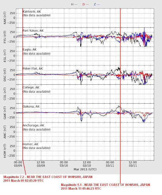
What was HAARP up to on January 12, 2010?  The official HAARP facility is located in Gakuna, Alaska.  The conspiracy theory claims that HAARP could be used as directed-energy weapon, weather control, an earthquake induction device and/or for mind control. http://www.haarp.alaska.edu/haarp/cam1.html 

HAARP is an “Ionospheric Heater” which is basically an array of antennas that can send a concentrated beam of RF energy into the ionosphere. It’s located in Alaska because areas near the magnetic poles have a lot of ionospheric activity. It’s not the only facility of its kind. EISCAT in Europe is a similar facility and a similar facility, Sura Ionospheric Heating Facility, is located in Russia. via http://phoenixaquua.blogspot.com/2009/12/haarp.html

Ionospheric Heating refers to artificially heating the Ionosphere, which is the upper most part of the atmosphere. ELF (Extremely Low Frequency) waves are used to literally boil the upper atmosphere. This lifts and changes the shape of the atmospheric gas clouds and can be used (theoretically) to control the weather. http://www.nerdmodo.com/2009/07/ionospheric-heating-and-weather-control/

 The morning of the quake here is what the skies looked like.

HAARP Quad All Sky Image on 1-12-10

http://137.229.36.30/cgi-bin/all-sky/image-browser.cgi   

And this is what the sky looked like at 17:04, about 5 hours before 21:53:10, the time of the quake.

HAARP Quad All-Sky 6 hours before quake

http://137.229.36.30/cgi-bin/all-sky/image-browser.cgi

These images are “fish-eye” views of the entire sky taken by the HAARP imager. The imager uses narrow-band interference filters, an image intensifier tube, and a cooled CCD camera to record the spatial distribution of various auroral and atmospheric emissions with very high sensitivity. It can detect optical emissions far below the visual threshold of the human eye. The 6300 angstrom red line results from excitation of atomic oxygen at altitudes of 200-300 kilometers. The 5577 A green line is an emission from atomic oxygen peaking at altitudes of ~110-150 km. Emissions from nitrogen (4278 angstroms) produce blue light at about 100 km altitude.

If these photos weren’t in black and white perhaps we would know what emissions these were. What is that burst of light there? Any ideas?

During active ionospheric research, the signal generated by the transmitter system is delivered to the antenna array, transmitted in an upward direction, and is partially absorbed, at an altitude between 100 to 350 km (depending on operating frequency), in a small volume a few hundred meters thick and a few tens of kilometers in diameter over the site. http://www.haarp.alaska.edu/haarp/tech.html

Where might there be a transmitter station near Haiti?  

In a previous inquiry on HAARP at https://ahrcanum.wordpress.com/2009/10/16/earthquake-haarp-connection-evidence/ HAARP One- Hop Experiment The South Pacific Buoy, deployed April 2004.  HAARP BUOY

The program will study radio waves generated by the HAARP transmitter in Alaska. We expect some waves to be ducted along the earth’s magnetic field lines – propagating out beyond five times the earth’s radius and returning to earth at a remote location in the South Pacific Ocean….  {the South Pacific is a hot bed of Seismic Activity} These waves will propagate through several important physical layers beyond the earth’s atmosphere. By operating a receiver at the magnetic conjugate point where the waves are most likely to return to earth, we will develop significant scientific understanding of those layers and the processes that affect them.http://www-star.stanford.edu/~vlf/buoy/ 

In the hours before the 7.o Magnitude look how many quakes were in Alaska, again the home of HAARP.  On January 12. http://earthquake.usgs.gov/earthquakes/recenteqsww/Quakes/quakes_all.php

MAP  5.9   2010/01/12 22:00:42    18.321    -72.848  10.0   HAITI REGION
MAP  7.0   2010/01/12 21:53:10    18.457    -72.533  13.0   HAITI REGION
MAP  2.5   2010/01/12 21:21:21    53.329   -165.837  16.6   FOX ISLANDS, ALEUTIAN ISLANDS, ALASKA
MAP  2.5   2010/01/12 20:52:50    38.993   -111.391  1.2   UTAH
MAP  2.9   2010/01/12 20:11:55    51.614   -175.792  35.3   ANDREANOF ISLANDS, ALEUTIAN IS., ALASKA
MAP  2.6   2010/01/12 20:09:22    53.405   -163.267  10.0   UNIMAK ISLAND REGION, ALASKA
MAP  2.6   2010/01/12 19:56:43    63.407   -151.217  10.3   CENTRAL ALASKA
MAP  3.3   2010/01/12 19:50:07    51.576   -175.369  17.7   ANDREANOF ISLANDS, ALEUTIAN IS., ALASKA
MAP  3.6   2010/01/12 19:20:23    60.084   -139.434  5.4   SOUTHERN YUKON TERRITORY, CANADA
MAP  3.8   2010/01/12 19:18:28    53.487   -163.415  11.4   UNIMAK ISLAND REGION, ALASKA
MAP  3.3   2010/01/12 18:28:18    55.584   -162.077  162.9   ALASKA PENINSULA
MAP  2.8   2010/01/12 18:26:26    54.096   -165.688  120.6   FOX ISLANDS, ALEUTIAN ISLANDS, ALASKA

 What was EISCAT up to?  Running tests of it’s own provided by http://www.eiscat.com/schedule/schedule.cgi

2010:01:12 Tue .       11111111111111  .       .       .       . ESR ASK UK(34),SW(18) 2010:01:12 Tue 111111111111 . . . . . UHF meteopolar SW(24)
2010:01:12 Tue .       .       .       .       .       .   22222 UHF meteopolar SW(24)
2010:01:12 Tue .       .       .       .       .       .      11 VHF Reimei_VHF NI(2)
2010:01:12 Tue .       .       .       .       .       .    1111 UHF Reimei_UHF NI(4)
2010:01:12 Tue .       .       22222   .       .       .       . ESR Reimei_ESR NI(2.5)

Meteopolar? http://www.eiscat.com/schedule/comment.cgi?fileName=2010011217646&Start=2200&End=2400  A study on meteor cross section form utilizing the polarization feature-

2010-01-12 0000-0600 experiment
2010-01-12 2200 – 2010-01-13 0700 experiment
2010-01-13 2200 – 2010-01-14 0700 experiment

An experiment done at 2200 hours, about two hours before the quake!

Also an ASK UK  experiment on the same day… Use of Radar Interferometry to Obtain High Resolution Svalbard Measurements.,,,

The experiment will employ both of the Svalbard antennas, together with
three recently installed panel arrays. It is the intention to use the LT4
pulse code, but this will change to the ARCS pulse code if high energy
precipitation studies are required. Use will also be made of the ASK and SIF
optical instruments, which are also located on Svalbard.
  This investigation is a collaboration with Sweden http://www.eiscat.com/schedule/comment.cgi?fileName=2010011223631&Start=0400&End=1100

And as for CERN experiments who can decipher this? http://greybook.cern.ch/programmes/EXP_NAM.html

Pioneering Ionospheric Radio Science Research for the Twenty-First Century    

Is there any danger we won’t live to see the 22nd century because of these atmospheric tests?  Time will tell.

One thing technology has achieved is the ability to see things via satellite from space.  To witness the devastation in Haiti is Google Earth with images at http://www.pcworld.com/article/186897/google_earth_reveals_the_devastation_in_haiti.html

2800 hits in an hour!  no one has anything to say?  comment, you know you want to!

Related Posts:  

Is HAARP causing Earthquakes & Ice to Melt?  https://ahrcanum.wordpress.com/2009/04/06/is-haarp-causing-the-earthquakes-volcanoes-to-erupt-and-the-ice-to-melt/

Italy Quake Warnings https://ahrcanum.wordpress.com/2009/04/08/italy-earthquake-warnings-by-giampaolo-guiliani-dismissed/

Italy Earthquake Conspiracy – https://ahrcanum.wordpress.com/2009/04/07/italy-earthquake-conspiracy/

Earthquake Epicenter near Nuclear Physics Lab https://ahrcanum.wordpress.com/2009/04/06/italy-earthquake-epicenter-near-nuclear-physics-lab/

WHAT Is That Noise in My Ears- https://ahrcanum.wordpress.com/2009/09/22/rining-noise-mosquito-whine-haarp-aliens-elf-implant/

South Pacific, Indonesia Quake Conspiracy https://ahrcanum.wordpress.com/2009/09/30/earthquake-conspiracy/ 

HAARP Causing the Quakes? https://ahrcanum.wordpress.com/2009/10/16/earthquake-haarp-connection-evidence/

Our thoughts and prayers are with the people of Haiti.

ALERT. UPDATED 2-27-2010. Chile & Japan Earthquake Conspiracy at https://ahrcanum.wordpress.com/?p=2839

  flag tounge

Open wide, say ahhh and check out more posts from Ahrcanum!

Our Swine Flu Report that began in April is at https://ahrcanum.wordpress.com/swine-flu-report    

Shaking, rattling and rolling into the conspiracy, truth and science of EARTHQUAKES, HAARP, EISCAT, Tesla, etc., with more posts at https://ahrcanum.wordpress.com/earthquakes-haarp/ 

Help spread the word.  SUBSCRIBE  NOW and Follow us on Twitter (by clicking in the side margin)  so you can get the latest updates as soon as they’re posted. Make sure to retweet, so all your friends get the heads up too.

Read Full Post »